
Last night I went on an after-dark reconnaissance ride carrying my trusty Garmin 500 (I was patted down at the gate, you don't want to know how I got it in there), riding extra slow to make sure it recorded every twist, every turn, every elevation change and each time I dodged a tree. Many spiders were killed in order for me to get this for you so here is the map:
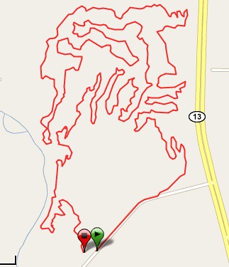
The lap distance is 7.25 miles (or 11.69 kilometers) and you can count on it taking about an hour to complete for beginners (if they make it at all), and 40 minutes for expert (not counting tire changes and resting periods) with sport somewhere in between. The race will have Beginners do 1 lap, Sport 2 laps and Expert has to suffer through 3 laps.
Oh, and either load your tires with Stans or bring lots of tubes. The thorns are out in full force.
Don't say you weren't warned.
If you don't hear from me again then Scott or Ryan reads my blog. Luckily I think I'm safe with that.


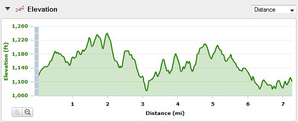
Man, that looks like ~2000ft elevation gain per lap. Is that right? How does the climbing compare to the castlewood state race?
ReplyDeleteIt's not even close to 2000; I zoomed way in. Here's the data for one of my pre-rides if you want to check it out: http://connect.garmin.com/activity/38898928
ReplyDeleteCan't find directions on MWFTS website. Can you help.
ReplyDeleteClick here for google map
ReplyDeleteParking is available at the trailhead located off Highway 13, three miles north of I-44. Watch for the brown highway sign marking the westbound turn-off. The trailhead is located just around the bend on the north side of this un-named road.